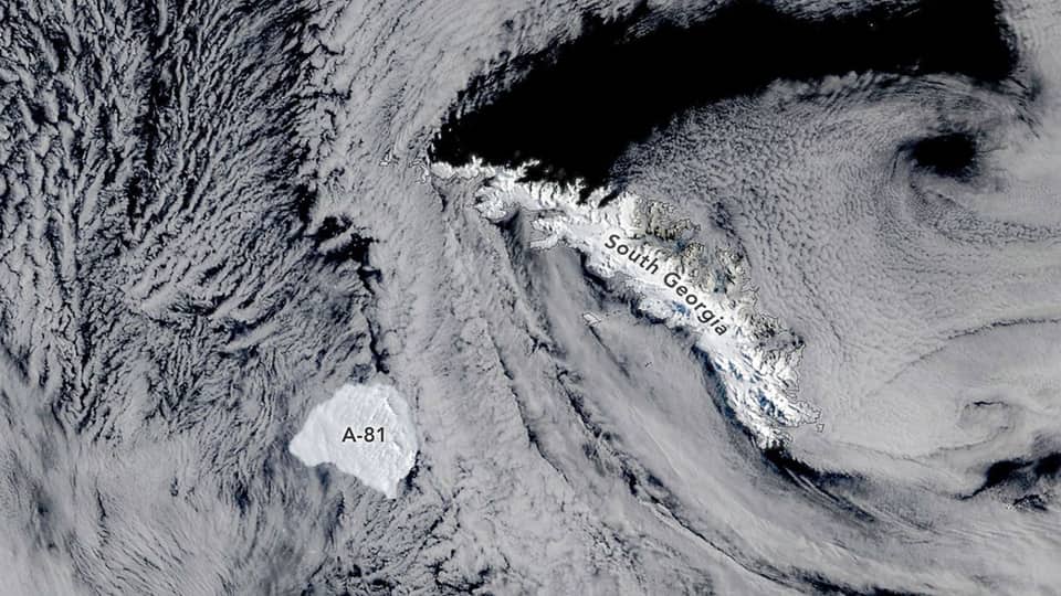
NASA Terra Satellite Captures Antarctic Iceberg A-81 Near South Georgia
A MODIS image captured October 20 shows A-81 near South Georgia after the iceberg drifted about 1,400 miles from Antarctica's Brunt Ice Shelf.
FlyMarshall Newsroom1 min read
Photo: NASA Earth Observatory/Michala Garrison
NASA’s Terra satellite captured iceberg A-81 near South Georgia on October 20, 2026, using its MODIS instrument. The iceberg calved from Antarctica’s Brunt Ice Shelf in January 2023 and has since crossed the Weddell and Scotia seas.
Key details
- A-81 covers about 600 square miles (1,550 square kilometers).
- Its route from the Brunt Ice Shelf to waters near South Georgia spans about 1,400 miles (2,300 kilometers) over roughly three years.
- NASA’s Terra satellite carries the MODIS instrument that captured the image.
A-81 traveled about 1,400 miles (2,300 kilometers) from the Brunt Ice Shelf between January 2023 and October 2026.
Why it matters
Satellite imagery gives researchers and the public a way to track large icebergs across remote Southern Ocean waters. A-81’s journey also documents the movement of a major iceberg from the Brunt Ice Shelf through two seas toward South Georgia.
What happens next
NASA’s satellite observations can continue to document A-81 as it moves through waters near South Georgia. What other Antarctic features will Terra capture next?
More stories
Rubin Observatory Data Reveals Distant Object 2026 ED138

Virgin Galactic Plans First Delta-Class Spacecraft Reveal for October 28

Bombardier and BAE Systems Plan Canadian Air-Combat Collaboration

Alaska Airlines Plans Anchorage–Tokyo Narita Route for 2027
American Airlines Dispatchers and Operations Specialists Approve New Contract